| | Tonight's Forecast: Snow before noon, then snow and areas of blowing snow. Cloudy, with a high near 30. Northeast wind 15 to 32 mph, with gusts as high as 53 mph. Chance of precipitation is 100%. New snow accumulation of 10 to 14 inches possible. WINTER STORM WARNING * WHAT...Heavy snow. Additional snow accumulations of 3 to 15
inches for a storm total of 5 to 20 inches. Winds gusting as
high as 50 mph.
* WHERE...Portions of northern New York and central, northeast,
northwest and southern Vermont.
* WHEN...Until 6 AM EDT Friday.
* IMPACTS...Travel could be very difficult. Travel on mountain
passes may be impossible at times due to localized blizzard and
whiteout conditions, especially this morning into early
afternoon. The hazardous conditions are most likely to impact
the commute this morning. Strong winds could cause tree damage
and adversely impact power restoration efforts.
* ADDITIONAL DETAILS...The heaviest snow is likely to occur early
this morning. Snowfall rates could exceed one inch per hour at
times. Later this afternoon, snow accumulations are more likely
on grassy surfaces and elevated terrain than on roadways. HIGH WIND WARNING * WHAT...East winds 25 to 35 mph with gusts up to 60 mph.
* WHERE...Eastern Addison, Eastern Chittenden, Eastern Rutland, and
Western Rutland Counties.
* WHEN...Until 10 AM EDT this morning.
* IMPACTS...Damaging winds will blow down trees and power lines.
Widespread power outages are expected. Travel will be difficult,
especially for high profile vehicles.
* ADDITIONAL DETAILS...Localized blizzard and whiteout conditions
are possible across the higher passes.
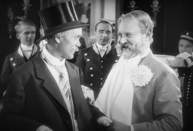
| | | | | FOLA Announces New Schedule FOLA (Friends of Ludlow Auditorium) has announced its first new schedule for 2024 following the well-received – and attended, Blue Jay Way Band Musical in March. In announcing the initial plans for the new season, Jim Alic, FOLA President, noted that "we've finally reached the point where we can look beyond Covid". He added that this initial schedule would be greatly enlarged in the coming months as people show an interest in returning to the Heald Auditorium. Scott Steans, FOLA's Program Director, indicated that plans are already underway for new events. "But we wanted to let the public know of the dates and times of the events that have been scheduled." Since this is a major political year, the schedule calls for two Candidate Forums where voters can hear directly from the candidates as to why they should be elected. A Primary Election candidates' Forum is scheduled for Thursday, July 18 at 7 PM. A General Election Forum will be conducted on Thursday, October 10 at 7 PM. The format and candidates for these events will be announced following the filing dates for the involved positions. Stearns also noted that FOLA's annual Silent Movie Festival would be returning to the auditorium on Saturday, August 24, starting at 7 PM. The silent movie selected is the classic film, "The Last Laugh", and will feature the return of Jeff Rapsis to provide the musical background. According to Stearns, future programs will likely include more musicals, some movies, plus new events co-produced with local organizations. These events and future new events for the year are available at https://fola.us. Pictured below is Emil Jannings from the silent movie, "The Last Laugh". The film is the story of the demotion of a
well-respected doorman at a major hotel who ended up having the last laugh. | | |
| | Tonight's Forecast: Sleet likely and rain and snow before 2pm, then sleet and a chance of snow. Cloudy, with a high near 34. Southeast wind 21 to 30 mph, with gusts as high as 46 mph. Chance of precipitation is 90%. New snow accumulation of less than one inch possible. WINTER STORM WARNING * WHAT...Heavy snow expected. Total snow accumulations of 6 to 15
inches, locally 18 to 24 inches. Winds gusting as high as 50
mph prior to heavy snow Wednesday evening.
* WHERE...Portions of northern New York and northeast Vermont.
* WHEN...From 11 AM Wednesday to 6 AM EDT Friday.
* IMPACTS...Travel could be very difficult. Travel on mountain
passes may be impossible at times due to localized blizzard and
whiteout conditions, especially overnight tonight. The
hazardous conditions is most likely to impact the Thursday
morning commute. Strong winds could cause tree damage.
* ADDITIONAL DETAILS...The heaviest snow is likely to occur
Wednesday night into Thursday. Snowfall rates could exceed 1
inch per hour at times. During the afternoon hours, snow
accumulations are more likely on grassy surfaces and elevated
terrain than on roadways. HIGH WIND WARNING * WHAT...East winds 30 to 40 mph with gusts up to 65 mph expected.
* WHERE...Eastern Addison, Eastern Chittenden, Eastern Rutland, and
Western Rutland Counties.
* WHEN...From 10 AM this morning to 10 AM EDT Thursday.
* IMPACTS...Damaging winds will blow down trees and power lines.
Widespread power outages are expected. Travel will be difficult,
especially for high profile vehicles.
* ADDITIONAL DETAILS...While the strong wind gusts are likely before
the wintry precipitation arrives this evening, localized blizzard
and whiteout conditions could lead to treacherous travel overnight
tonight especially across the higher passes.
| | | | | Farm & Wilderness Conservation is seeking contracted boat access greeters for the Woodward Reservoir and Lake Ninevah Aquatic Invasive Species Prevention Programs. Greeters provide courtesy boat checks, collect important data about boater use and visitation, and prevent the spread of aquatic invasive species. Position runs May-October 2024, $15/hr. Training is provided.
Required Qualifications:
At least 18 years of age
Ability to work independently at the boat access for a minimum of 4-hour shifts
Ability to use smartphone or tablet apps to collect survey data (training provided)
Comfortable speaking with the general public and asking survey questions
To learn more and apply, follow this link: https://www.fwcvt.org/fw-conservation-blog/public-access-gre...
Questions? Email conservation@farmandwilderness.org or call 802-422-3761 | | |
| | Tonight's Forecast: A slight chance of rain showers after 4pm. Mostly cloudy, with a high near 45. East wind 6 to 12 mph. Chance of precipitation is 20%. New rainfall amounts less than a tenth of an inch possible. WINTER STORM WATCH * WHAT...Heavy snow and mixed precipitation possible. Total snow
accumulations of 6 to 18 inches and ice accumulations of a
light glaze possible. Winds could gust as high as 50 mph.
* WHERE...Portions of northern New York and central, northeast,
northwest and southern Vermont.
* WHEN...From Wednesday morning through late Thursday night.
* IMPACTS...Travel could be very difficult to impossible. The
hazardous conditions could impact the morning or evening
commute. Gusty winds could bring down tree branches.
* ADDITIONAL DETAILS...Snow is likely to be wet in nature. The
potential for snowloading may increase the risk for power
outages.
| | | | | Maybe you met Pete Hill from the transfer station, around town or grew up with him. He had been having health issues of late and had to give up his job at the transfer station. Pete really enjoyed this job and meeting all of you. His birthday is April 14th, and would enjoy getting cards (card shower)from you. If not a birthday card, maybe even a Get Well card would be nice to help cheer him up as he is currently in the hospital.
Many thanks, Dianne Surething
David "Pete" Hill
1407 Old Turnpike Rd
Mt Holly VT 05758 | | |
| | | | | |